קובץ:Nautz1827.jpg

לקובץ המקורי (2,312 × 1,680 פיקסלים, גודל הקובץ: 2.74 מ"ב, סוג MIME: image/jpeg)
| זהו קובץ שמקורו במיזם ויקישיתוף וניתן להשתמש בו גם במיזמים אחרים. ראו גם את דף תיאור הקובץ המקורי. |
תקציר
| תיאור |
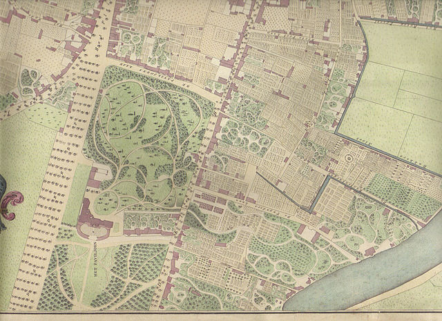
Southern portion of Nautz 1829 map of Haarlem showing Welgelegen as it was in 1827. Map date: 1829 Colored copper engraving by W.C. van Baarsel in Amsterdam. Source: Ferdinand Joseph Nautz(1785-1841) surveyor. Nautz was a member of a group of surveyors hired in 1817 to map the Dutch towns in order serve as a basis for taxes. The hand-colored and hand-drawn maps were created in 1822 by Nautz and his colleagues H.C. van Dooren and A. van Diggelen. They are in the possession of the National Archives. For the town of Haarlem, Nautz created a set of maps of Haarlem where not only ownership rights, but also houses were drawn. Quite popular, these maps were reproduced by book sellers and sold at the time for 3 guilders to travelers as the first city-maps. This set of maps belongs to the city of Haarlem, and has been used as the basis for city planning as late as 1900. In the archive museum of Haarlem, a model of the city is on show based on this map. |
||||||||||||||||
| תאריך יצירה |
Archiefdienst voor Kennemerland/Historische Museum Zuid-Kennemerland, Haarlem |
||||||||||||||||
| מקור | נוצר על־ידי מעלה היצירה Scanned from 2002 reproduction of one of many copies of the 'Nautz of Haarlem' in possession of North Holland Archives. | ||||||||||||||||
| יוצר |
|
||||||||||||||||
רישיון
|
יצירה זו נמצאת בנחלת הכלל במדינת המקור ובמדינות אחרות בהם תקופת זכויות היוצרים היא משך חיי היוצר ו-70 שנה (או פחות) מפטירתו.
| |
| הקובץ הזה זוהה כקובץ חופשי מכל מגבלה ידועה תחת חוק זכויות היוצרים, כולל כל הזכויות הקשורות והסמוכות. | |
היסטוריית הקובץ
ניתן ללחוץ על תאריך/שעה כדי לראות את הקובץ כפי שנראה באותו זמן.
| תאריך/שעה | תמונה ממוזערת | ממדים | משתמש | הערה | |
|---|---|---|---|---|---|
| נוכחית | 18:22, 22 בינואר 2007 | | 1,680 × 2,312 (2.74 מ"ב) | Jane023 | == Summary == Southern portion of Nautz 1829 map showing Welgelegen as it was in 1827 1829 Colored copper engraving by W.C. van Baarsel in Amsterdam. Source: Ferdinand Joseph Nautz(1785-1841) surveyor Nautz was a member of a group of surveyors hired in 18 |
שימוש בקובץ
הדפים הבאים משתמשים בקובץ הזה:
שימוש גלובלי בקובץ
אתרי הוויקי השונים הבאים משתמשים בקובץ זה:
- שימוש באתר de.wikipedia.org
- שימוש באתר en.wikipedia.org
- שימוש באתר uz.wikipedia.org